Unveiling the Geological Marvels of Kauai 🌋🌴
Kauai, the oldest of Hawaii’s main islands, boasts a diverse range of geological formations that are a result of its formation from Hawaiian volcanoes. The island is primarily composed of Kauai shield lavas, which are part of the Honolulu Volcanics volcanic series. In addition to this, Niihau shield basalts and postshield alkaline suite samples can also be found on the island.
These samples have provided valuable information about Kauai’s geological history. Members of the postshield alkaline suite have been identified through checks of their chemical and isotopic types, revealing a wide range of abundances and isotopic ratios. Makaweli and Niihau alkaline samples are also present on Kauai, adding to the diversity of its geological formations.
The geology of Kauai is fascinating due to its unique history. The island was formed by volcanic activity that began over five million years ago. As magma rose up from deep within the earth’s mantle, it created fissures in the ocean floor through which lava flowed out and solidified into rock formations.
Over time, these rocks were eroded by wind and water, creating stunning natural wonders such as Waimea Canyon and Na Pali Coast. These formations provide a glimpse into Kauai’s geological past and offer visitors an opportunity to witness nature’s power at work.
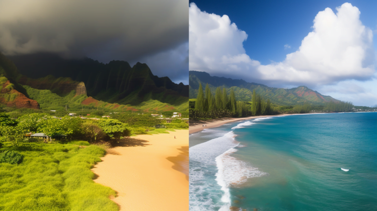
One example is Waimea Canyon, known as the “Grand Canyon of the Pacific.” This canyon was carved out by thousands of years of erosion caused by water flowing down from Mount Waialeale – one of the wettest places on Earth. Its vibrant reds and oranges make for a breathtaking sight against lush greenery.
Another example is Na Pali Coast – a 17-mile stretch along Kauai’s northwest shore that features towering cliffs rising up from crystal-clear waters below. These cliffs were formed over millions of years through tectonic plate movement and erosion caused by wind and water.
Kauai’s geological formations are not only visually stunning but also provide valuable information about the island’s past. By studying the rocks and minerals found on Kauai, scientists have been able to gain insight into the island’s formation and evolution over millions of years.
A Short Geologic History of Kauai: Understanding the Formation Process
Shield-Building: The First Stage of Kauai’s Formation
Kauai, the oldest island in the Hawaiian chain, has a geologic history spanning over 5 million years. The island formed through a series of volcanic eruptions and subsequent erosion. Kauai’s evolution can be divided into three main stages: shield-building, post-shield, and rejuvenation.
During the shield-building stage, lava flows from numerous vents built up to form a broad shield-shaped volcano. This stage lasted for about 1.5 million years and created the bulk of Kauai’s landmass. The shield-building stage was characterized by low-viscosity basaltic lava that flowed easily across the surface, creating gently sloping landscapes.
Post-Shield: The Second Stage of Kauai’s Formation
The second stage of Kauai’s formation is known as the post-shield stage. During this time period, volcanic activity shifted to smaller vents on the flanks of the shield volcano. These eruptions produced more explosive magma types such as andesite and dacite which are more viscous than basaltic lava.
This change in magma composition led to steeper slopes and more rugged terrain on Kauai. Erosion also played a significant role during this stage, carving deep valleys into the landscape.
Rejuvenation: The Final Stage of Kauai’s Formation
The third and final stage of Kauai’s formation is known as rejuvenation. During this time period, new volcanism occurred along fractures within the existing volcanic edifice or along newly formed fissure zones.
Isotopic compositions of rocks on Kauai provide insight into the island’s formation process and fractionation during magma generation. Pb isotope ratios suggest a common mantle source for all Hawaiian volcanism including that at Kauai; however, low Th and trace element ratios indicate melting from a depleted mantle source.
Isotopic data also suggests that Kauai’s volcanism was influenced by the subduction of the Pacific Plate beneath the North American Plate. The melting of the mantle wedge above the subducting plate produced magma that rose to the surface and formed Hawaiian volcanoes.
The Formation of the Hawaiian Islands: Discovering the Basics
The Hawaiian Islands are a group of volcanic islands located in the Pacific Ocean, with Hawaii being the largest and most active. The formation of these islands is due to a hotspot in the Earth’s mantle, where magma rises to the surface and creates new land over time.
Hawaiian Island Formation
The Hawaiian Islands were formed by volcanic activity that began around 5 million years ago. The process began when magma from deep within the Earth’s mantle rose towards the surface, causing eruptions that created underwater mountains. Over time, as more eruptions occurred, these mountains grew taller until they eventually broke through the ocean’s surface to form islands.
The island chain itself stretches for over 1,500 miles and consists of eight main islands: Hawaii (also known as the Big Island), Maui, Oahu, Kauai, Molokai, Lanai, Niihau and Kahoolawe. Each island has its own unique geological features and distinct character.
Honolulu on Oahu
Honolulu is located on Oahu, which is part of the Hawaiian Island chain. This island is known for its beautiful beaches and rich cultural history. Honolulu itself is home to many historic sites such as Pearl Harbor and Iolani Palace. It also boasts some of Hawaii’s best surfing spots like Waikiki Beach.
Haupu on Kauai
Haupu is a mountain located on Kauai island in Hawaii. This island is known for its stunning natural beauty and diverse wildlife. Haupu offers breathtaking views of both land and sea from its summit at 2,120 feet above sea level.
Hawaiian Island Study
The study of Hawaiian Island formations has revealed patterns and variations in major element sources including basanites and other volcanic materials that provide insight into the center of the Earth’s mantle. Researchers have found that there are trends in chemical composition across different parts of Hawaii that suggest variations in magma source and melting processes.
Top 5 Kauai Geologic Formations
Waimea Canyon: The “Grand Canyon of the Pacific”
Waimea Canyon is one of Kauai’s most awe-inspiring geological formations. Known as the “Grand Canyon of the Pacific,” it stretches approximately 10 miles long and 3,000 feet deep. This stunning canyon was formed by a combination of volcanic activity and erosion from the Waimea River.
The canyon’s vibrant colors are truly mesmerizing – reds, browns, and greens intermingle to create a breathtaking natural landscape. Visitors can hike along several trails in the area to get up close and personal with this magnificent formation. One popular trail is the Waimea Canyon Trail, which offers stunning views of both Waimea Canyon and Waipo’o Falls.
Na Pali Coast: Towering Cliffs Above the Ocean
The Na Pali Coast is another one of Kauai’s most iconic geological formations. This stunning coastline is made up of towering cliffs that rise up to 4,000 feet above the ocean. These cliffs were formed by a combination of volcanic activity and erosion from the ocean.
Visitors can explore Na Pali Coast on foot via hiking trails or by boat on guided tours. No matter how you choose to experience it, Na Pali Coast is sure to leave you in awe at its sheer beauty.
Spouting Horn: A Natural Blowhole
Located on Kauai’s southern coast, Spouting Horn is a natural blowhole that was formed by waves eroding lava rock over time. When waves crash into the opening, water is forced through the hole and creates a loud hissing sound.
This unique geological formation has become somewhat of a tourist attraction due to its impressive display when waves are strong enough to create large sprays of water shooting out from Spouting Horn’s opening.
Wailua Falls: Double Waterfall Beauty
Wailua Falls is a double waterfall located in Wailua River State Park that drops approximately 80 feet into a pool below. The falls were formed by volcanic activity and erosion from the Wailua River.
Visitors can view the falls from a lookout point above or take a short hike down to the base of the falls for an up-close experience. The beauty of Wailua Falls is truly breathtaking, making it one of Kauai’s most beloved geological formations.
Maha’ulepu Beach: Unique Geological Formations
Maha’ulepu Beach is known for its unique geological formations, including limestone cliffs, sea caves, and sinkholes. These formations were created by a combination of volcanic activity and erosion from the ocean.
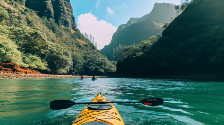
Visitors can explore these geological wonders on foot via hiking trails or by kayak on guided tours. Maha’ulepu Beach offers visitors a chance to witness firsthand the power of nature in shaping our world.
Exploring Waimea Canyon: One of Kauai’s Most Spectacular Landscapes
Waimea Canyon is a natural wonder that has captivated visitors’ hearts for generations. It is one of the most spectacular landscapes in Kauai, featuring a 14-mile long and 1-mile wide canyon that is up to 3,600 feet deep. Let’s explore this breathtaking landscape in detail.
Waimea Canyon Basalt: The Formation
The canyon is made up of Waimea Canyon Basalt, which was formed by lava flows from the nearby Paniau volcano over five million years ago. The basalt formations are unique and have been shaped by several geological events over time. The red coloration of the rocks comes from iron oxide minerals present in the lava flows. Visitors can marvel at these geological wonders while exploring the canyon.
Hiking Trails: A Must-Do Activity
Visitors can explore Waimea Canyon by hiking one of the many trails available, such as the popular Canyon Trail that offers stunning views of the canyon and its vibrant reds, greens, and browns. The trailhead begins at Pu’u Hinahina lookout point and descends into the canyon floor through lush vegetation and towering rock formations. This hike is considered moderate to strenuous due to its steep inclines and declines but provides hikers with an unforgettable experience.
May: The Best Time to Visit
May is a great time to visit Waimea Canyon as it is typically less crowded than other months and offers cooler temperatures for hiking. Visitors can enjoy their hikes without worrying about extreme heat or overcrowding on trails.
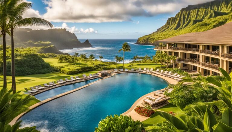
Suites with Stunning Views
For those looking for a luxurious stay near Waimea Canyon, there are several suites available at nearby resorts that offer stunning views of the canyon from the comfort of your own room. These suites provide guests with an unparalleled view of Kauai’s natural beauty while enjoying top-notch amenities.
Pu’u Hinahina Lookout Point: A Popular Destination
One of the most popular lookout points in Waimea Canyon is Pu’u Hinahina lookout, which offers panoramic views of the canyon and its surrounding valleys. This lookout point provides visitors with a bird’s eye view of the canyon’s deep reds, greens, and browns. It is an ideal spot for taking memorable photographs.
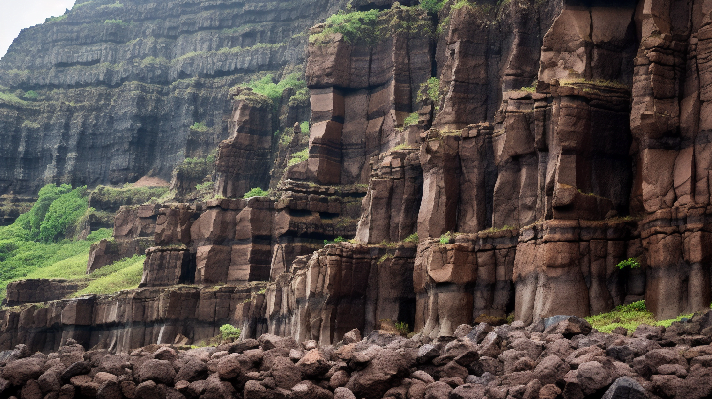
The Majestic Na Pali Coast: A Geological Marvel on Kauai’s North Shore
Na Pali Coast is a geological wonder located on the north shore of Kauai, featuring towering cliffs that rise up to 4,000 feet above sea level. Its unique and awe-inspiring formations are a testament to the power of nature and the forces that shape our planet.
Formation of Na Pali Coast
The formation of Na Pali Coast is attributed to the collision of the Pacific and North American tectonic plates, resulting in the uplift of the Napali Formation and subsequent erosion by the sea. The Napali Formation consists mainly of volcanic rocks such as basaltic lava flows, pyroclastic deposits, and volcaniclastic sediments. The uplifted landmass was then subjected to intense weathering and erosion by wind and rain, which carved out deep valleys and steep ridges.
Geological Features
The Na Pali Coast is home to several unique geological features that make it a must-see destination for geology enthusiasts. One such feature is the North Arch, which is a natural arch formed by erosion. The North Arch stands at over 60 feet tall and spans nearly 30 feet across. It serves as a reminder of the power of water in shaping our landscape.
Another notable feature is Hanapepe Salt Beds, which are remnants of an ancient salt-making industry. The beds were formed when seawater was trapped in shallow pools along the coastlines during low tide. As water evaporated under intense sunlight, salt crystals were left behind in large quantities. These salt beds have been used for centuries by Native Hawaiians as a source of salt for preserving fish and other foods.
Surrounding Geological Formations
The Na Pali Coast is surrounded by other notable geological formations that add to its beauty and intrigue. To its east lies Koloa Volcanics, which consist mainly of basaltic lava flows and cinders. To the west, there are the volcanic peaks of Haleakala, Mauna Kea, Mauna Loa, and West Maui. These peaks are part of the Hawaiian Islands’ volcanic chain that stretches for over 1,500 miles in the Pacific Ocean.
The neighboring islands of Niihau and Molokai also contribute to the geological diversity of the region. Niihau is a small island with a unique geology characterized by uplifted coral reefs and limestones. Molokai is home to West Molokai Volcano, which last erupted around 1.5 million years ago.
Awe-Inspiring Wailua Falls: Understanding Its Formation Process
Waves and Thin Flows: The Formation of Wailua Falls
Wailua Falls is a natural wonder located on the island of Kauai, Hawaii. It is a stunning sight to behold, with water cascading down from a height of 80 feet into a pool below. But how did this awe-inspiring waterfall come to be?
The formation process of Wailua Falls began millions of years ago when thin lava flows covered the area. These thin flows were not thick enough to create volcanic mountains but instead created flat plains that extended outwards. Over time, these flows were eroded by waves and water, which carved out the lush valleys surrounding the falls.
Flank Collapses: Shaping Wailua Falls
But it wasn’t just waves and water erosion that contributed to the formation of Wailua Falls. Flank collapses also played a significant role in shaping this natural wonder. A flank collapse occurs when part of a volcano’s side collapses due to gravity or other forces.
The most recent flank collapse at Wailua Falls occurred approximately 120,000 years ago. This event created the current shape of the falls as we know it today. The collapse caused an indentation in the land where water could accumulate and flow over the edge, creating the waterfall we see today.
Visiting Wailua Falls: Hiking and Lookout Points
Now that we understand how Wailua Falls was formed let’s discuss how visitors can experience its beauty up close. One way is by hiking down to the bottom of the falls. This hike is not for beginners as it requires descending steep terrain and navigating slippery rocks near the base of the falls.
For those who prefer to view from afar, there are several lookout points available that offer stunning views of Wailua Falls from above. Visitors can take pictures or simply stand in awe as they witness one of nature’s most impressive sights.
The Mysterious Spouting Horn: A Fascinating Geologic Phenomenon on Kauai’s South Shore
The Niihau Shield Lavas: A Product of Postshield Volcanism
Located on Kauai’s South Shore is a unique geological formation known as the Spouting Horn. This fascinating natural wonder is the result of the interaction between waves and a submerged lava tube, resulting in a solitary wave that shoots water up to 50 feet into the air. The Spouting Horn sits atop the Niihau shield lavas, which were formed by postshield volcanism after the eruption of the shield volcano that created Kauai.
The Niihau shield lavas are composed of postshield rocks that were formed by the Hawaiian plume, a mantle source responsible for creating many of Hawaii’s shield volcanoes. The plume is believed to be located at a depth of around 1,800 miles beneath Earth’s surface and has been active for at least 70 million years. As magma rises from the plume center towards the surface, it creates a chain of islands and seamounts known as the Hawaiian-Emperor seamount chain.
Submarine Cones: An Intriguing Result of Plume Activity
The Spouting Horn is just one example of many submarine cones that were formed along the plume track. These cones are created when lava erupts underwater and solidifies quickly due to rapid cooling. Over time, more eruptions build up layers upon layers until they reach above sea level.
Interestingly enough, despite being part of Kauai’s volcanic history, Niihau shield lavas are considered primitive mantle material. This means they have remained mostly unchanged since their initial formation millions of years ago. Scientists believe this is because they were formed early on in Hawaii’s volcanic history before significant changes occurred in mantle composition.
The Solitary Wave: A Natural Phenomenon
What makes Spouting Horn so unique is its solitary wave – a result of interaction between incoming waves and the submerged lava tube. As waves approach the shore, they enter the tube and compress air trapped inside. This compressed air shoots out of the top of the tube, creating a powerful jet of water that can reach up to 50 feet in height.
Visitors to Kauai’s South Shore can witness this incredible natural phenomenon for themselves by visiting Spouting Horn Park. In addition to admiring the Spouting Horn itself, visitors can also enjoy stunning ocean views and learn about the area’s cultural significance through interpretive signs located throughout the park.
Unraveling the Secrets of Mount Waialeale: One of the Wettest Places on Earth
Volcanic Formation of Mount Waialeale
Millions of years ago, the formation of Mount Waialeale began on the sea floor due to volcanic activity. As magma rose from the Earth’s mantle, it cooled and solidified, forming a shield volcano. Over time, tectonic movements caused the mountain to rise above sea level and become one of the highest points in Kauai.
The Wettest Place on Earth
Mount Waialeale is known as one of the wettest places on earth, receiving an average annual rainfall of over 450 inches. This is attributed to its location in the path of trade winds that blow across the ocean towards Hawaii. These moisture-laden winds are forced upwards by the mountain’s height and form clouds that release their water as rain.
Unique Geology
Studies have shown that Mount Waialeale’s unique geology contributes to its ability to attract and retain large amounts of water. Partial melting of rocks beneath the surface creates spaces where water can accumulate. High volatile contents in these rocks contribute to increased water retention.
Water Resource Management
Understanding Mount Waialeale’s geological formations and water cycle is crucial for predicting and managing water resources in other parts of the world. By studying how this mountain attracts and retains large amounts of water, scientists can gain insight into how other areas with similar geological features might behave.
Embarking on a Journey Through Kauai’s Enchanting Geology
Koloa Volcanic Series: A Prominent Geological Feature
The Koloa volcanic series is one of the most prominent geological features on Kauai. It includes the Koloa lavas, which are believed to have erupted between 4.7 and 3 million years ago. These lavas cover much of the southern part of the island, including Poipu and Koloa.
The Koloa lavas are basaltic in composition and were likely formed from a rift zone that extended across the southern part of the island. The lava flows are typically thin and widespread, forming gently sloping hillsides that are covered in vegetation. Some of these lava flows can be seen at Mahaulepu Beach, where they form dramatic cliffs along the coastline.
East Molokai Volcanic Field: Linking to Kauai’s Geology
Kauai’s geology is closely linked to the East Molokai volcanic field, which has been active for millions of years. This volcanic field extends from east Molokai to west Maui and includes several submarine volcanoes that have contributed to the formation of Kauai.
The oldest rocks on Kauai date back about 5 million years and were likely formed by submarine eruptions near what is now known as Niihau Island. Over time, these rocks were uplifted by tectonic forces, exposing them above sea level.
Submarine Lavas Contributing to Distinctive Rock Formations
Kauai’s unique location and submarine lavas have contributed to its distinctive rock formations and volcanism. The island is located at a triple junction where three tectonic plates meet – Pacific Plate, North American Plate, and Philippine Sea Plate.
This location has resulted in complex interactions between these plates over millions of years, leading to extensive volcanism and diverse rock formations on Kauai. For example, some areas on the island are dominated by rejuvenated stage lavas, which are formed when older lava flows are reactivated and erupt again.
Embarking on a Journey Through Kauai’s Enchanting Geology
Embarking on a journey through Kauai’s enchanting geology offers a fascinating glimpse into the island’s geological history and natural beauty. Visitors can explore the diverse range of geological formations on the island, including volcanic rocks, lava flows, and rejuvenated lava suites.
One popular destination is Waimea Canyon, often referred to as the “Grand Canyon of the Pacific.” This stunning canyon was carved out over millions of years by erosion from the Waimea River and features colorful rock formations that offer insight into Kauai’s geologic past.
Another must-see attraction for geology enthusiasts is Na Pali Coast State Park. This park features towering sea cliffs that rise up to 4,000 feet above sea level and showcase some of the most dramatic rock formations on Kauai.
Conclusion: Discovering the Beauty of Kauai Geological Formations
Kauai is a geological wonderland that boasts some of the most spectacular landscapes in the world. From the majestic Na Pali Coast to the awe-inspiring Waimea Canyon, Kauai’s geologic formations are a testament to the power and beauty of nature.
Understanding how these formations came to be is an incredible journey that takes us back millions of years. It’s amazing to think that what we see today was once nothing but molten lava erupting from deep beneath the ocean floor.
As we explore Kauai’s geological history, we discover how its unique location on top of a hot spot has created a chain of volcanic islands stretching across the Pacific Ocean. We learn about how tectonic plate movements have shaped and shifted these islands over time, creating mountains, canyons, valleys, and coastlines unlike anywhere else on Earth.
From a technical standpoint, studying Kauai’s geology is fascinating. But beyond that, it offers us a chance to connect with something much larger than ourselves. It reminds us that we are just small specks in an infinite universe and that nature will always be more powerful than anything we can create.
Whether you’re a scientist or just someone who loves exploring new places, Kauai’s geological formations offer something for everyone. They inspire us to appreciate the natural wonders around us and remind us of our place in this vast universe.
So next time you find yourself on this beautiful island paradise, take some time to explore its geological wonders. You won’t regret it!